Sunday, October 16, 2011

Daytona Beach, FL to Los Angeles, CA


Larry receiving "the map" from Tracy

Team Big Dog (me, Big Al, Capt. Jack, Peter the Wuss, and Larry the new recruit.

The end.


"Considerable cloudiness through late morning then becoming partly cloudy. Highs in the mid 80s. Northeast winds 10 to 15 mph."


Last night was the farewell dinner for the riders and staff, hosted by CrossRoads at the Holiday Inn. Tracy gave out certificates to the riders who then spoke eloquently about their experiences. Once again, CrossRoads Cycling Adventures did a great job and this rides' staff (Tom, Mac, Robin, and Carol) were fantastic. Larry was awarded the route map - well done and welcome to Team Big Dog.


I'm off to the Daytona Beach airport for my flights back to California; the riding is done.

Totals:
21 Days of riding; 3 rest days.
13 states.
1,628 miles; 94:42 hours; 30,701' climb; 89,406 Calories.
Bonus miles: 84.6 miles (South Portland and Ocracoke Island).
Six DQ chocolate milk shakes.
ZERO FL*TS!


The late, comedian George Carlin had a famous routine called, "Seven Dirty Words You Can Never Say on Television." As I rode down the east coast, I thought about the "dirty words you can never say on a bike tour:"

9. Head wind
8. Chip seal
7. Interstate (on this ride SR 17A)
6. Rain
5. Detour (aka bonus miles)
4. Mosquitoes
3. Buffet or continental breakfast
2. Rumble strips
1. Fl*t (Jack had eleven fl*ts; the last one as he rolled into the hotel in Daytona.)

Saturday, October 15, 2011

St. Augustine, FL, to Daytona Beach, FL

Riders from the cross country trip in 2010
Stuart, Bill, Chris, Doug, Jan, Bill, Michel

Riders from 2009
Champ, Mike, Jack, Al, me, Tom, Peter (front), Tom, Bob, Hank

Team Pedigree
Doug, Bob, Tom,Bill,Chris, Larry, Champ

Cupcakes?

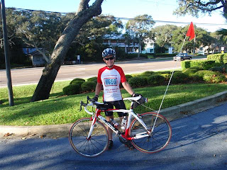
Team Big Dog at the end of the ride.  (Al, me, Peter, and Jack)


"Mostly sunny. Highs in the lower 80s. Northeast winds 10 to 15 mph."


Coming out of St. Augustine, we eventually left town and turned onto SR A1A, along the coast with ocean views, sand dunes, and beach houses. The pavement was smooth and there was little traffic early in the morning. We had our last SAG stop - cupcakes anyone? Leaving the SAG, Team Big Dog put the metal to the pedals and burned down the road into Daytona Beach. It's Biketober Fest and Daytona is swamped with motorcycles. Peter complained about the smell of exhaust and cheap perfume. We're all deaf in our left ears from passing Harleys.


The last day of riding, the last SAG stop, the last dinner together - where did the time go? It seems like only yesterday that we left Maine on our ride down the east coast and it seems like we've been riding forever. What a great trip with old and new friends.


Daytona Beach, FL (1876)
Population 64,211 (city), 496,575 (metro); elevation 5'
The hard-packed sand beach allows cars to drive on the beach in restricted areas.


54.1 miles; 2:44 hours; 260' climb; 3,329 Calories.

Friday, October 14, 2011

Fernandina Beach, FL, to St. Augustine, FL

"Mostly sunny. Highs in the lower 80s. Northwest winds 10 to 15 mph."

Not a cloud in the sky, warm, gorgeous day - what more could we ask for? At mile 20, we were to board a ten-minute ferry for the crossing from St. John's River to Mayport. The ferry runs every thirty minutes at :15 and :45 on the hour. Big Al was hot to make the 10:15 ferry - since we didn't sign out until a little after 9:00, we would have to ride hard to make it. I opted to take it slow and told the team that I would sign them out, giving them a few extra minutes on the road. I rolled out of the hotel with Larry, who almost immediately had a mechanical problem with his bike computer and pulled over to fix it. So, I rode on and caught Stuart, but he was riding a little slow for conditions, so I pulled ahead of him. Looking at my watch, I figured there was no sense in poking along, so I took off and time-trialed for the twenty miles to the ferry, covering the distance in less than an hour. As we waited for the ferry, a few more riders showed up - Stuart arrived just as they were closing the gates and a bunch of riders didn't make the time cut and were at the gate as the ferry departed; if only they had ridden a tad faster.

After departing the ferry, the newly united, Team Big Dog joined SR A1A towards St. Augustine; this part of the ride was busy commercial, strip malls, lining both sides of the road. Eventually, we found ourselves on the coastal road with large houses between us and the beach. One section of the road looked a lot like Ocracoke Island, with no houses, a long, sand dune on one side and marshes on the other. We kept up a nice pace into St Augustine and stopped at a SubWay for lunch before proceeding to the hotel. It was a fun ride, with the race to the ferry and nice roads to the end.

PS Someone referred to the bridges we've ridden over as the "Florida Alps!" The rest of the roads have been flat, flat, flat.

St Augustine, FL (1565)
Population 12,975; elevation 5'
The oldest continuously occupied European-established city and port in the continental US.

59.8 miles; 3:06 hours; 334' climb; 3,753 Calories.

Thursday, October 13, 2011

Brunswick, GA, to Fernandina Beach, FL


Big Al and I

My peeps - finally in Florida

Fernandina Beach


"Partly cloudy. Slight chance of showers in the morning...then slight chance of showers and thunderstorms in the afternoon. Highs in the mid 80s. Southwest winds 10 to 15 mph. Chance of rain 20 percent."


Al to waiter: "We're riding our bicycles from Maine to Florida."

Waiter to Al: "Now, why would you want to do that? They have these things, with wheels, called cars."


We left the hotel at 9:00 AM this morning. With only 61 miles to ride, we didn't want to arrive at the hotel before our rooms were ready. Some of the riders went across the street to a Waffle House for breakfast while others opted for the breakfast provided by the hotel.


Blue skies, fluffy white clouds, and sunshine were the order of the day. Our route took us back on SR17 and miles of pine forest on both sides of the road. I was the last rider out of the hotel and after one red light and stopping to take a picture, found myself DFL (dead freakin' last). I took my time, no rush to get to the hotel and eventually caught up to Mac and Big Al who had stopped to take a picture. The three of us rode together, stopping for some swings in a roadside playground. When we got to the SAG stop, Peter and Jack were waiting for us and the four of us continued at a leisurely pace down the highway. At mile 42, we crossed into Florida and paused for the traditional state sign picture. We then left SR17 (yay!) and turned onto SR A1A (yikes!). Some construction, logging trucks, and many cars made for some unpleasant riding until we passed the hotel for the entrance to a Dairy Queen - large, chocolate milkshake, please. Our hotel is a short distance from the beach.


Fernandina Beach, FL
Population 11,487; elevation 25'
Isle of eight flags: France, Spain, Great Britain, Spain (again), Patriots of Amelia Island, Green Cross of Florida, Mexico, Confederate States of America, United States of America.


62.6 miles; 3:44 hours; 518' climb; 3,164 Calories.

Wednesday, October 12, 2011

Savannah, GA, to Brunswick, GA

"Areas of fog in the morning. Mostly cloudy with a slight chance of showers. A slight chance of thunderstorms in the afternoon. Highs in the upper 70s. West winds 5 to 10 mph. Chance of rain 20 percent."

It rained just before dawn, so the streets of Savannah were wet when we left the hotel. We only experienced a few sprinkles on our way to Brunswick under cloudy skies - not enough to count as rain. It was warm and humid.

Highlights of the day were fog in the morning, waiting for a train, and lunch at a Piggly Wiggly (ugh!) with vultures picking over the trash. Are we having fun? You betcha.

Tip: When riding in the rain, your cycling shoes will get wet, very wet; to dry them, stuff them with crumpled up newspapers, let sit for a hour and repeat a couple of times. The newsprint will soak up and remove most of the moisture so your shoes will be reasonably dry for the next day.

Tip: When riding in the rain, use a shower cap over your helmet to keep the rain off the top of your head.

When Al told the waitress at dinner we were riding bicycles from Maine to Florida, she said, "You must really like each other!" I hadn't thought of the ride in those terms. She's right.

Brunswick, GA (1738)
Population 16,326 (city), 103,841 (metro); elevation10'
The city lays claim to Brunswick stew, a tomato-based stew containing various types of lima beans, corn, okra, and other vegetables, and one or more types of meat. Most recipes claiming authenticity call for squirrel or rabbbit meat, but chicken, pork, and beef are also common ingredients.

83.3 miles; 4:39 hours; 647' climb; 4,574 Calories

Tuesday, October 11, 2011

Savannah, GA - rest day


It was still wet in Savannah when I went in search of my morning coffee and it rained for a brief time after breakfast. After checking the weather channel's radar, I decided it was going to be dry enough to take a walk. Our hotel is next to the historic riverfront district and I went in search of the waving girl statue.


Florence Martus (1868 – 1943), aka "the Waving Girl", took it upon herself to be the unofficial greeter of all ships that entered and left the port of Savannah, between 1887 and 1931. Martus would wave a handkerchief by day and a lantern by night. According to legend, not a ship was missed in her forty-four years on watch. The statue of Martus and her faithful collie is by Felix de Weldon who also sculpted the USMC War Memorial. Legend has it, the reason she greeted ships was because she had fallen in love as a young girl with a sailor and wanted to be sure he would find her when he returned. On September 27, 1943 Liberty ship SS Florence Martus was named in her honor.


The Talmadge Memorial bridge under threatening skies

The old river front has been preserved and is filled with trendy restaurants and shops.

Monday, October 10, 2011

Beaufort, SC, to Savannah, GA

Looks like rain to me.


Larry (Big Dog) and Hank (My Hero)

Sam and Al cleaning their bikes before taking them into the hotel.


"Showers with a slight chance of thunderstorms. Rain may be heavy at times. Highs in the mid 70s. Breezy. Northeast winds 15 to 25 mph with gusts up to 40 mph. Chance of rain near 100 percent."


Wet!


It was only 46 miles by bicycle to Savannah, so we didn't depart the hotel in Beaufort until 9:00 AM. It was raining when we left the hotel in Beaufort and it continued to rain until the final few miles into Savannah. The roads were narrow and there was a lot of traffic. I think the motorists were sympathetic to the poor, wet cyclists and behaved themselves. There weren't any opportunities for photos on today's ride - the Welcome to Georgia sign was in the middle of a bridge where you couldn't stop to take a picture.


Tomorrow is our last rest day. Only four more days of riding and we will be at the end of our trek. Each day, like clockwork, Big Al says, "Hey, Jim, guess what. We're riding our bikes from Maine to Florida!" I will miss hearing that when I get home.


This area is of some interest to me, personally. My ancestor, Matthew Lyle, immigrated to Georgia in 1768 from Northern Ireland and received a grant of 100 acres in what is now Jefferson County, Georgia. Matthew Lyle was a Loyalist during the Revolution and served as a Lieutenant Colonel in the British militia in Georgia. After the war, he took his family to London to apply for a pension for his losses in America incurred because of his loyalty to the Crown, and then to Northern Ireland to await settlement of his claim. The family returned to America in 1796 and settled in South Carolina, where Matthew Lyle died in 1831 in Kershaw County.


Savannah, GA (1733)
Population 136,286; elevation 49'
Hometown of the founder of the Girl Scouts of America, Juliette Gordon Low.
A large port city, Savannah is home to International Paper and Gulfstream Aerospace.
The book, Midnight in the Garden of Good and Evil, was about a murder that took place in Savannah. Do you remember The Lady Chablis?


47.2 miles; 2:39 hours; 875' climb; 2,580 Calories.

Sunday, October 9, 2011

Charleston, SC, to Beaufort, SC

"Mostly cloudy with a chance of showers with a slight chance of thunderstorms. Highs around 80. Breezy. Northeast winds 15 to 25 mph with gusts up to 35 mph. Chance of rain 50 percent."

Big Al's wife, Roddie, joined him yesterday from Michigan. Peter, Larry, and I went to dinner with them at a very nice restaurant in the heart of historic Charleston.

It's only 80 miles from Charleston to Beaufort. After the last two days' rides of 111 and 119 miles, eighty miles seems short. There was not much to photograph today. We rode through the suburbs of Charleston and then joined SR once more, but enjoying parallel country roads where possible. The picture above pretty much looks like what we saw, with the exception of the clowns lining the road. Skies were partly cloudy, but the cloud cover increased as we neared Beaufort and we were sprinkled on for a little while. As soon as we turned into the hotel, we stopped at a sandwich place for subs, chips, and sodas. Roddie showed up with a pecan pie and boiled peanuts to finish off the meal. We continue to have favorable winds but the next few days are forecast to be rainy; fortunately, it's a warm rain.

Beaufort, SC (1711)
Population 12,361; elevation 10'
"Beaufort is located on Port Royal Island, in the heart of the Sea Islands and the Lowcountry. The city is renowned for its scenic location and for maintaining a historic character through its impressive antebellum architecture. The city is also known for its military establishments, being located in close proximity to Parris Island and a U.S. Naval Hospital, in addition to being home of the Marine Corps Air Station Beaufort."

81.0 miles; 4:18 hours; 847' climb; 4,737 Calories.

Saturday, October 8, 2011

Little River, SC, to Charleston, SC

"Mostly sunny in the morning...then becoming partly cloudy. Highs in the upper 70s. Northeast winds 10 to 15 mph."

Route rap: Each night, before dinner, the group gets together, usually in the hotel's lobby, to go over the next day's route sheet, pointing out any important cautions or locations of Dairy Queens.

We had a nice tailwind all the way to Charleston. It was cool when we left the hotel, but it soon warmed up under sunny skies. Our route took us through Myrtle Beach, which is a beach resort with miles of hotels, condominiums, restaurants, miniature golf, etc. We then turned back onto SR17 for many, many miles of what Doug (Britain) calls a dual carriageway - translation, four-lane highway. Traffic was Saturday morning light and we made good time, but there wasn't much of note to look at. As we approached Charleston, traffic picked up, but Jan, who is from the area, had suggested an alternate route that took us away from construction and over the Cooper River Bridge (aka the Arthur Ravenel Jr. Bridge). Completed in 2005, the CRB is beautiful, but for me the ride across was terrifying; I don't particularly like heights and it was windy.185 feet above the river. The bridge is 2.9 miles long and cost $700 million dollars.

Charleston, SC (1670)
Population 120,083; elevation 20'
(metropolitan Charleston has a population of 659,191)
Recognized as the "best mannered city in the US."

119.3 miles; 6:21 hours; 754' of climb; 7,075 Calories.

Friday, October 7, 2011

Jacksonville, NC, to Little River, SC

"Sunny. Highs in the mid 70s. Northeast winds around 10 mph."

At dinner last night:

Al to the waitress: "We're riding our bicycles from Maine to Florida."

Waitress: "What, you ain't got no cars?" "You see me walkin', my car is broke."

You know you're in the South when:

1. Grits is on the breakfast menu.
2. Iced tea comes pre-sweetened (and the waitress doesn't ask how you want it).
3. Spanish moss is hanging from the oak trees.

Today's ride from Jacksonville to Little River was a long one, but a favorable tailwind helped the riders. We were in traffic until we got out of Jacksonville and then rode on a deserted road through a pine forest. Big Al complained about how boring it was to ride mile after mile, seeing the same thing, over and over. Little did he know what was coming. Eventually, we came out of the forest and hit the freeway with lots of traffic and a narrow shoulder (be careful what you wish for, Al). The remainder of the route took us on SR17, a four lane highway with rumble strips in the middle of the shoulder. I would have preferred the road through the pines. After riding more than 100 miles in just over five hours, we stopped for lunch at a Bagel shop. The bagel shop was out of bagels but had regular bread to make our sandwiches. The remaining eight miles to the hotel was interesting in the number of golf courses that we passed.

Little River, SC
Population 7,027; elevation 39'
Little River is just south of the North Carolina - South Carolina border, and north of Myrtle Beach.
For several years, LR was home to video poker gambling, but protests from the local churches led to its ban. Casino boats still operate in the coastal waters.

111.0 miles; 5:57 hours; 1,119'climb; 6,242 Calories.

Thursday, October 6, 2011

Ocracoke Island, NC, to Jacksonville, NC

"Sunny. Highs in the mid 70s. Northeast winds 10 to 15 mph"

Today's ride started with a 2:15 hour ferry ride to Cedar Island. The ferry left Ocracoke at 7:30 and the CrossRoads' staff organized breakfast for us on the boat. Once we landed on Cedar Island, Team Big Dog didn't waste any time moving on down the road. We had a favorable tailwind most of the day, but some of the time it was in our faces or from the side. Our route took us through marsh lands and by isolated homes. Many of the homes had stacks of debris stacked next to the highway: couches, refrigerators, carpet, dry wall, etc. ruined by Hurricane Irene. We then hit the coastal development in Morehead City before joining the busy highway to Jacksonville. Jack had a flat at the top of a huge bridge that spans the intracoastal waterway; we stopped to help him fix the flat before moving on. This was a double Dairy Queen day! There was one DQ adjacent to the SAG stop and I rushed in to get a chocolate milk shake before the group left. At mile 68, we stopped for lunch at a second DQ for lunch, where I had another milk shake and a cheeseburger.

Jacksonville, NC (1757)
Population 70,145; Elevation 15'
Home to Camp Legeune Marine Corps Base - Hoorah!

87.0 miles; 4:27 hours; 831'climb; 5,331 Calories.

Wednesday, October 5, 2011

Ocracoke Island, NC - rest day

"Sunny. Highs in the mid 70s. North winds 10 to 15 mph."

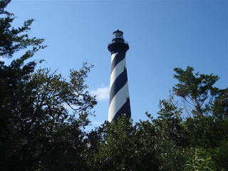
Today was a rest day. Because we had missed Cape Hatteras because the new bridge wasn't open, I decided to ride up to Hatteras and back. After breakfast, Jack, Al and I started a leisurely ride up Ocracoke Island. Although the town of Ocracoke is privately owned, the rest of the island is part of the Hatteras National Seashore. My concept of the Outer Banks was a narrow, continuous sand dune, bordered on both sides by water. While much of the OB does resemble my mental image, much of it is wooded or occupied by houses. Ocracoke Island is a little more than 12 miles long. I stopped to see the island ponies, descendants of Spanish horses left on the islands. I looked at my watch and realized that I was going to miss the ferry to Hatteras if I didn't hustle, so I raced the final few miles and just made the 10:00 AM ferry. Jack and Al were no where to be seen. Stuart was already at the ferry when I arrived, so I joined him for the ride up Hatteras to the famous lighthouse. Several years ago, erosion threatened to destroy the lighthouse, so they moved it several hundred yards inland! The characteristic black and white barber pole paint job was to make Hatteras distinguishable from the sea. Since I don't like high places, I waited for Stuart to climb to the top of the lighthouse. Afterwards, we stopped at a grocery store to buy lunch which we consumed in the parking lot. On the way back to the ferry, we spotted Barbara and Beverly headed north, obviously headed for the lighthouse as well. The return trip to Ocracoke was fast because we had a tail wind. What a great rest day.

53.9 miles; 316 hours; 255' climb; 2,818 Calories